

From Manual Passenger Counting to 3D Passenger Tracking
When AMORPH started working with airport passenger flow solutions in 2011, one of our first projects at Frankfurt Airport highlighted an important challenge: accurate simulation and forecasting depend on reliable measurement data.
At the time, automated passenger measurement technologies were still limited, and manual counting was often necessary to validate passenger flows and simulation results.
Today, airports have access to a much wider range of technologies for measuring passenger movement, queues, waiting times and occupancy. The challenge has shifted from simply collecting data to choosing the right technology for each operational use case.
LiDAR passenger tracking provides an increasingly flexible approach. By measuring movement in three-dimensional space, LiDAR can support multiple airport use cases, from passenger flow and queue measurement to occupancy and movement analytics, while maintaining a privacy-first approach.
There is no one-size-fits-all solution, but LiDAR seems to cover most cases!
Therefore, Amorph Systems has focused on using LiDAR-based solutions in airports to address the broadest range of use cases shown below.
Why Airports Need Continuous Passenger Flow Measurement
Passenger counting is only one part of understanding how people move through an airport.
For airport operations, continuous passenger flow measurement can provide insight into how passengers move between terminal areas, where queues are developing, how long passengers wait, and how occupancy changes throughout the day.
This information can support a wide range of operational use cases, including check-in and security queue measurement, passenger flow analysis, capacity management, boarding processes and terminal planning.
LiDAR is particularly interesting for these applications because it measures position and movement in three-dimensional space without relying on conventional video imagery or signals from passengers’ personal devices.
This enables a privacy-first approach to passenger tracking, where the operational focus is on movement, flow and spatial behavior rather than identifying individual travelers.
When combined with airport planning, simulation and analytics, this measurement data can also help airports better understand patterns in passenger demand and support more accurate operational planning.
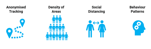
LiDAR enables people tracking on a new level – totally GDPR compliant!
How Can Airports Measure Passenger Flows?
Airports can use different technologies to measure passenger movement, queues and occupancy. The right approach depends on the use case, required level of accuracy, terminal environment, installation conditions and privacy requirements.
Common approaches include camera-based systems, Wi-Fi or Bluetooth-based measurement and LiDAR-based 3D tracking.
Camera-based systems can detect and analyze passenger movement within defined areas. Depending on the technology and installation, they can provide detailed information about occupancy, movement and queues. However, sensor positioning, field of view, lighting conditions and privacy requirements need to be considered when designing the deployment.
Wi-Fi and Bluetooth-based approaches use signals from passengers’ mobile devices to estimate movement and location. These technologies can be useful for understanding broader movement patterns, but their suitability depends on factors such as device availability, signal behavior and the level of spatial accuracy required.
LiDAR-based systems measure the position and movement of objects in three-dimensional space. This makes LiDAR particularly suitable for use cases where airports need to understand detailed passenger movement, dynamic queues or occupancy across larger and more complex areas.
Rather than asking which technology is universally best, airports should evaluate which measurement approach provides the right combination of coverage, accuracy, privacy, infrastructure requirements and operational value for the specific use case.
How Does LiDAR Technology Work?
LiDAR (Light Detection and Ranging) uses laser pulses to measure the distance between a sensor and objects in its environment. By continuously measuring these reflections, the sensor creates a detailed three-dimensional representation of the surrounding area, known as a point cloud.
The point cloud provides the spatial data, but the sensor alone does not create operational insights. 3D perception software is needed to detect and classify objects and track their movement through the monitored area.
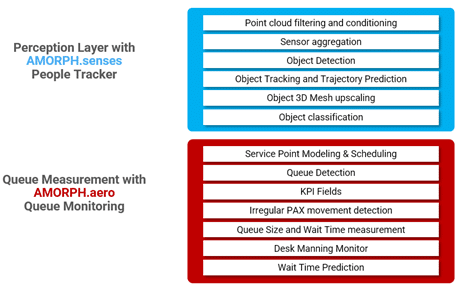
For airport passenger tracking, this means detecting people and following their movement through three-dimensional space without relying on conventional video imagery to identify individual travelers.
The resulting movement data can then be processed for specific airport use cases, such as passenger flow measurement, queue detection, waiting-time measurement, occupancy analysis, and movement patterns.
A LiDAR-based passenger tracking solution therefore consists of three main layers:
1. LiDAR sensors – capture the surrounding environment as 3D spatial data.
2. 3D perception software – detects, classifies, and tracks people and other relevant objects.
3. Use-case analytics – transforms tracking data into operational information such as passenger flows, queues, waiting times, and occupancy.
What Are the Advantages of LiDAR for Airport Passenger Tracking?
LiDAR offers several characteristics that make it particularly suitable for measuring passenger movement in complex airport environments.
3D spatial tracking
LiDAR measures the position and movement of people in three-dimensional space. This allows airports to understand not only how many passengers are present, but also how they move through a monitored area.
Dynamic queue measurement
Airport queues do not always remain within predefined boundaries. They can grow, change direction or overlap with other passenger flows. 3D tracking can help follow these changing movements and associate passengers with relevant processing areas.
Coverage of complex areas
Depending on the sensor configuration and terminal environment, LiDAR can monitor larger or irregular areas where fixed measurement zones may be difficult to maintain. Multiple sensors can also be combined to provide continuous tracking across wider spaces.
Privacy-first measurement
LiDAR measures spatial information rather than conventional video imagery. This makes it possible to analyze passenger movement, queues and occupancy without relying on images that directly reveal a person’s appearance.
Multiple use cases from the same spatial data
The same 3D tracking environment can support different operational applications, including passenger flow analysis, queue and waiting-time measurement, occupancy monitoring and movement analytics.
For airports, the value of LiDAR therefore goes beyond passenger counting. It provides detailed spatial data that can help build a more complete understanding of how passengers move through terminal processes.
How AMORPH.senses Turns LiDAR Data into Operational Insights
A LiDAR sensor provides detailed 3D spatial data, but turning that data into useful information for airport operations requires perception, tracking, and analytics.
AMORPH.senses provides the software layer for processing sensor data, detecting and tracking objects in 3D and transforming movement data into information that can be used for specific operational applications.
For airports, this can include passenger flow measurement, queue and waiting-time analysis, occupancy monitoring and movement analytics.
Sensor-independent architecture
AMORPH.senses is designed to work with different sensor technologies and hardware providers. This allows airports to select sensors according to the requirements of the individual environment and use case rather than building the entire solution around a single hardware supplier.
Flexible multi-sensor deployments
Different areas of an airport can have very different measurement requirements. AMORPH.senses supports deployments in which multiple sensors can be combined to provide the coverage required for complex terminal environments.
From 3D tracking to airport applications
The platform processes spatial data and converts it into information that can be used by operational applications and analytics. This creates a flexible foundation for developing different use cases from the same 3D perception environment.
For airports, this means that LiDAR passenger tracking does not have to remain an isolated measurement system. The resulting data can become part of a broader passenger flow and airport operations environment.
Explore LiDAR Passenger Tracking for Your Airport
Every airport environment is different. Terminal architecture, passenger processes, measurement areas and operational objectives all influence the right sensor and deployment concept.
Talk to our team about how AMORPH.senses can support LiDAR-based passenger flow measurement and 3D tracking for your airport.
Contact the AMORPH team → NOW!
Frequently Asked Questions About LiDAR Passenger Tracking at Airports
What is LiDAR passenger tracking?
LiDAR passenger tracking uses 3D spatial data to detect and follow passenger movement through an airport environment. Rather than identifying individual travelers, the technology can measure movement, passenger flows, queues and occupancy to provide operational insights.
How does LiDAR track passengers at airports?
LiDAR sensors use laser pulses to measure the position of objects in three-dimensional space. 3D perception software processes this spatial data to detect people and track their movement through monitored areas. The resulting data can then be used to analyze passenger flows, queues, waiting times and occupancy.
Can LiDAR measure airport queues and waiting times?
Yes. LiDAR-based 3D tracking can follow how passengers move through processing areas and how queues develop over time. This can support queue-length and waiting-time measurement at locations such as check-in, security checkpoints and other passenger processing areas.
Does LiDAR passenger tracking identify individual passengers?
LiDAR passenger tracking does not need to rely on conventional video imagery to analyze passenger movement. The operational focus can remain on spatial information such as position, movement, flow and occupancy rather than on identifying individual travelers. This makes LiDAR well suited to privacy-first passenger flow applications.
What can airports use LiDAR passenger tracking for?
Airports can use LiDAR passenger tracking for applications including passenger flow measurement, queue and waiting-time analysis, occupancy monitoring, check-in and security processes, boarding areas and terminal movement analytics. The resulting spatial data can also support broader airport planning and operational applications.